The Lea: A Suburban Industrial River, 1855-1915.
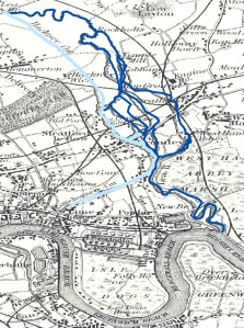
I am working on a paper about the transformation of the Lower Lea River (including the Bow Back Rivers and Bow Creek) into an industrial river network, during the second half of the nineteenth century and the early twentieth century. As I write the paper I will be creating some GIS maps of the area from that I will post on this blog. I’ve included the abstract for this paper below. Here is a very early map of the rivers I’m researching.

The River Lea, London’s second river, passes through the city’s northern and eastern suburbs before it flows into the Thames Estuary, through the industrial landscape of West Ham. During the second half of the nineteenth century, industrial growth transformed the lower reaches of the Lea into a collection of industrial streams. At the same time, the Lea shaped the economic development and built environment of the new suburbs developing along its banks and in its wetlands.
The history of the Lower River Lea and West Ham provide an interesting comparison to those studying much larger rivers in Europe or North America. The small size of the river and its rapid transformation and integration with the suburban landscape, provide a unique scale to examine the process and consequences of industrialization.
The Lea and its wetlands covered a large section of West Ham, as it divided into half a dozen streams, locally known as the Stratford Back Rivers, in the northwest of the suburb, before reconnecting into one riverbed at Three Mills Island. The abundance of tidal back rivers, along with jurisdictional independence from London’s building regulations, facilitated the development of the industrial economy on the marshlands of the lower Lea. The vast majority of the factories relied on the back rivers to carry cheap coal and other raw materials, so the wandering streams determined the layout of the industrial district. Like the factories, much of the residential growth took place on the wetlands of the Lea. The significant suburban growth within wetlands and even within the river itself, created a unique hybrid suburb landscape, where factories were intermixed with impoverished clusters of homes, farms and allotment gardens, and patches of surviving marshlands.
Unlike the standard narrative of suburban growth, workers and factories populated the Lower Lea Valley, not middle class families looking to escape the unpleasant inner city. Upstream from West Ham, the Lea supported a variety of suburban development, including small pockets of industry and new working class commuter suburbs. During this time, engineers remade much of the Lea’s beds into canals, water companies diverted much of the river to supply growing population and the suburbs used the river to dispose of the resulting sewage. The ensuing overuse of the Lea created crisis after crisis during the rapid growth of Outer London in the second half of the nineteenth century.
The paper will focus on the patchwork landscape the Lea created in West Ham, and the hybrid and degraded industrial river, suburbanization created out of the Lea. My research relies on a wide range of engineering, municipal and parliamentary records, local and national newspapers, and a detailed GIS database that tracks the changing suburban landscape from 1867 to 1915. I will try and post a few updates as I write this paper along with some maps of the Lea during the transformation from rural wetlands to a suburban industrial landscape.