Preparing the landscape

One place, many stories · about 1900

Above the
Channelsea

Stand on the sewer. Look around a landscape that kept London working.

Scroll to begin · drag to look around

Interpretive reconstruction
S · 184°
Explore the district
Tide · Low water

90-second cycle · illustrative levels. Old Lea above the lock and marsh ditches stay steady.

Drag or arrow keys to look · WASD to move · Q/E lower / higher when flying

South side

01The working river

A river at work

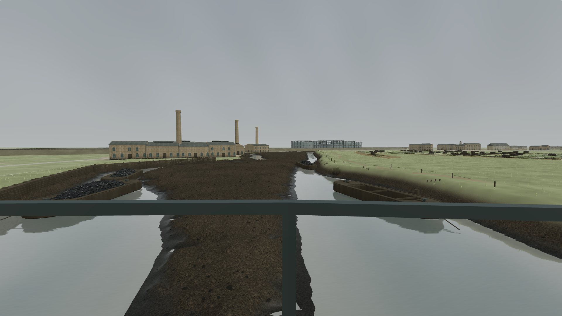
Look south from the crossing. Barges used these waterways to carry supplies to riverside works. The river linked local jobs to the needs of a much larger city.

Look a little deeper

The wide 1900 photograph shows exposed riverbed, east-bank works and Bromley’s holders beyond them. Gardens lay south of the pumping station on the western side. Railway routes follow the OS map: one behind the factories, another across the distance north of Bromley gasworks. Garden beds, railway levels and building elevations remain interpretations.

Book figure 4; OS London VIII.32 and VIII.42; author’s identification of the gardens.

02London’s sewage

Where the sewage went

Abbey Mills lifted sewage into London’s higher-level drainage system. You are standing above part of that system: the Northern Outfall Sewer. A public walking route ran over infrastructure carrying the city’s waste.

Look a little deeper

The pumping station lies west of this crossing. Its arched windows, steep roofs, dormers and central lantern draw on the modern photograph; its two lost chimneys draw on the period view. Their dimensions and visibility still need to be checked against the maps and period photographs.

Book chapter 3; Historic England listings for Abbey Mills and the sewer bridge.

03Making gas

Fuel for a growing city

Beyond the bend lay Bromley’s gasworks. Gas holders stored fuel before it reached homes and workplaces. This was one part of an industrial landscape that brought employment and environmental costs close together.

Look a little deeper

Seven holder locations now form a group, using a site plan and the listed records. Their two-tier frames represent the earlier arrangement; gas-bell heights are estimates. Nine holders existed historically, so this group remains incomplete. West Ham Gas Works stood in another direction, beyond the houses to the north-west.

Historic England holder listings; Bromley gasworks site plan, figure 2-2.

04Homes & gasworks

Living beside the works

This was a place to live as well as work. Four pairs of houses stood on Abbey Lane, with the West Ham gasworks nearby. Homes, industry and the sewer shared a small area.

Look a little deeper

The eight Abbey Lane houses date to 1865. Their positions, surrounding terrace rows and six West Ham gas-holder circles follow OS sheets revised in 1893. Roberts Road, Beck Road and Lucas Road lay beyond the sewer to the north-west; more housing stood across the river on Abbey Road. Mill Meads remained open. The map registration is approximate; heights, household divisions and facade details are interpretations.

OS London VIII.32 and VIII.22, revised 1893, published 1895; Historic England: 116–130 Abbey Lane, listing 1080983.

05The northern streets

Streets beyond the railway

Look north and north-east. Long rows of houses spread beyond the railway goods yard, with more streets east of Abbey Road. Industry stood beside a densely inhabited neighbourhood.

Look a little deeper

The northern housing follows rows on OS sheet VIII.22 and the adjoining area shown in the supplied map mosaic. The railway yard separates groups of streets; Abbey Marsh remains open farther east. These are simplified building-row envelopes, with estimated heights and facade divisions. Distant buildings overlap from this low viewpoint, so the location map shows their arrangement more clearly.

OS London VIII.22 and the author-supplied OS map mosaic. Approximate registration; interpreted building elevations.

06The corn mill

An older working river

Just north of the crossing stood Abbey Mill, labelled as a corn mill on the OS map. Milling was part of the river’s working history long before the pumping station and gasworks.

Look a little deeper

The book’s mill illustration dates to about 1800. Its windmill is not evidence of a surviving windmill a century later, so this scene shows only a provisional mill building at the mapped site.

OS London VIII.32: Abbey Mill (Corn); book figure 1, c1800.

07Look for yourself

Explore the district

Choose an area or factory from “Fly to”, then use the pad or WASD to move. Drag to look around. Use Higher / Lower or E / Q to change height. You can fly across the landscape and through buildings; this is a viewing tool. Reset returns you to the bridge.

A place to walk. A place of work.

West Ham’s “boulevard”

In 1902, J. J. Terrett mocked the idea of this sewer-top walk as a grand promenade. His description brought gasworks, chemical works and the pumping station into one uncomfortable view. This landscape asks a question that runs through Jim Clifford’s book: how did the industries serving a growing city shape life beside the river?

Based on West Ham and the River Lea, chapter 3. Terrett’s description was a political criticism, not the voice of every resident.

1865
The eight Abbey Lane houses were built, a short walk from the West Ham gasworks.
1900–02
The sewer bridge beneath your feet was rebuilt and widened. The scene spans that change.
Nine
Gas holders once stood at Bromley. Seven are modelled; two lost holders are not yet placed.

The evidence & the gaps

How do we know?

You are on the Northern Outfall Sewer crossing. River edges and factory plots come from the supplied historical GIS. Building shapes, heights and the bridge deck are provisional. Nothing here is a photograph: every surface is modelled, and every estimate is recorded.

Watching the tide

The Tide control raises and lowers water through an illustrative range, exposing the mud shelves and showing the lower marsh behind the riverbanks. Its 90-second cycle is a visual demonstration, not a historical tide prediction. The Old Lea above the Limehouse Cut lock stays at its retained level. Marsh ditches stay separate because their tidal connections have not been established.

A location, not yet a photograph match

The bridge’s approximate listed grid reference, TQ 38900 83209, anchors the scene. You can move within a 48 × 11 metre rectangle inside the bridge walkway, starting near its south side. This is an exploration limit, not a measured historical bridge boundary. Its eye level, the deck alignment and all building dimensions are estimates for this sketch. We have not yet fitted the historic photographs to this camera.

A changing crossing

The bridge was rebuilt and widened in 1900–1902. Our working period spans that change; the walkway, enclosed sewer and bank supports are a simplified reconstruction whose dimensions and rebuilding phase remain provisional. Historic England: sewer bridge.

Maps give us the ground plan

River and industrial-site outlines come from the author’s supplied GIS. Housing rows and six West Ham gas-holder circles are traced from inspected scans of London VIII.32 and VIII.22, revised 1893 and published 1895. Their alignment uses approximate sheet bounds and still needs refinement. Mill Meads remains open, as the map shows. The brown river surface interprets exposed bed; it is not a measured low-water shoreline.

Buildings are still study models

The housing follows mapped row envelopes; its heights, repeated windows, chimneys and household divisions are interpretations informed by local photographs. Abbey Mills’ architecture draws on modern and period views. Factory buildings still need individual identification. Seven Bromley holders form the southern group; two lost holders are not yet modelled. Gas-bell levels, frame detail and colours remain estimates. Abbey Lane houses · Abbey Mills · Bromley gas holders.

The raised sewer, gardens and railways

The sewer follows mapped bends and continues in both directions. Its height follows the author’s description of a walkway near roof level; the bank profile and distant continuations are estimates. Rail routes follow sheets VIII.32 and VIII.42. The author identifies gardens south of the pumping station; individual beds and sheds are interpreted. Abbey Mill is shown at its mapped site, without assuming that the windmill pictured around 1800 survived into this scene.

Photographs guide the model

The author identifies different gasworks in the two views: the 1902 close-up looks toward West Ham Gas Works to the north; the wide 1900 view shows Bromley to the south. The exact photograph viewpoints remain to be matched. Barges, timber retaining edges, exposed mud, factory windows and surface colours in this study interpret the photographs; individual positions, dimensions and colours remain estimates. Modern photographs help with surviving details. No photograph textures are used in this sketch. The overcast light, industrial haze, weathered brick and discoloured water interpret the bleakness of the photographs and the book’s account of sewage and chemical industry; exact colours and pollution levels cannot be recovered from these views.

Coal from sea to river

Representative steam colliers unload into Thames lighters; a steam tug and open barges illustrate the onward journey into the Lea waterways. The vessels, workers and handling gear draw on the supplied paintings, engravings and photographs. Ship sizes, colours, loads and moorings remain interpretations. The coal-whipping prints date from 1871 and 1874; the Bonner Bridge barge photograph is labelled 1907. The much later Hackney Power Station view is used only to compare hull and cargo details. The 1946 photograph of MV Mitcham is also a later comparison for proportions. Lloyd’s Register Foundation: coal handling · Greenwich Industrial History: steam colliers.

This prototype is for local review. Publication rights for the supplied GIS still need to be recorded. Historic England listing information: Open Government Licence v3.0.

Find your bearings

Explore the district

North is up. Click the map to fly there; the dot and gold cone show your position and view. The wider region uses flat building outlines from 1891–96. These will gradually be replaced by 3D models. Ground beyond the detailed district is provisional while historical elevations are recorded.

● Water■ Industrial sites▬ Housing rows┄ Railway■ Garden beds◆ Camera